NOTE TO ALL NEW READERS:

Our blog may look dormant and as if no one is posting anything new, but in fact, we (Laurie and Bill) are currently working on moving our blog, "I Can't Drive 55" from Wordpress to Blogger. So if you see a new post that was dated in July please be patient with us as we move the massive text and pictures to this site. Once we start posting "brand new" posts, we will remove this "Note." Thanks for you patience!

Friday, July 30, 2010

A Little More Desert and Wood

Some have wondered how we can remember so much of the detail of our trip from 25 years ago.  Truth be told, we don’t always remember *everything* until we read our journal.  We kept a journal throughout our trip across the country, and we wrote in it every night.  We took turns doing this, and on July 21st, Bill made the following journal entry:

"Got up at 6:00 a.m.  I got up before Laurie did, had 2 cups of coffee before she opened her eyes."

We didn’t use an alarm clock except for those days when we were driving to the next destination and wanted to arrive by a certain time.  On this particular day, Bill’s internal clock went off early!

We went back out to the National Park to start sightseeing at the exact point that we left off the day before when Laurie’s contacts had started to bother her.  The first stop was to take the walking trail out to the Crystal Forest.

Crystal Forest

The Crystal Forest is a place where a lot of the petrified wood has been vandalized.  Many throughout the years had carted off a lot of this precious rock.  In fact there were loads of logs within this area that the mark of having been chiseled and broken up for the vandals to cart off the quartz crystals was evident.

Broken Pieces of Petrified Wood

Here lies an area that has the beginning effects of the badlands of the painted desert.  The logs lie out in the vast expanse among the silt-like formations.  The logs are those little dots you see in the background.

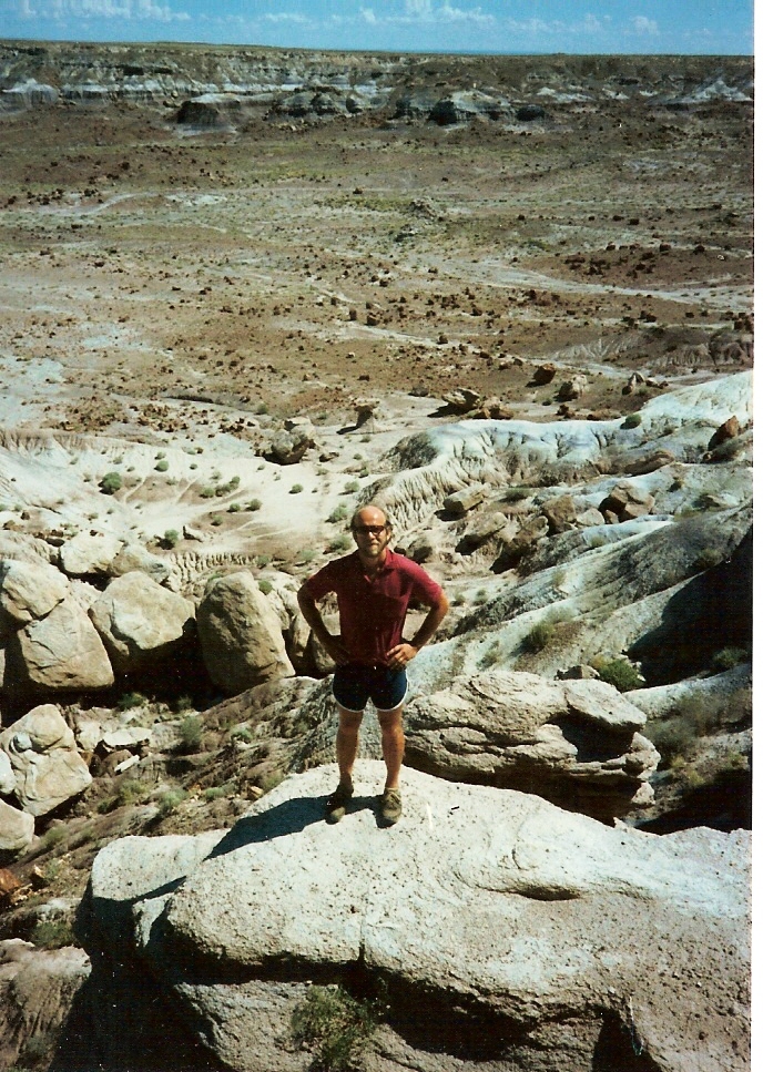
Badlands with Petrified Wood Logs

The next location that we rode the motorcycle to was the Jasper Forest.   Jasper Forest has a wonderful overlook that lets the visitor view the vast land of the badlands within the painted desert as a complete overview.

Jasper Forest Overlook

While we were in the area of Jasper Forest, Bill spied a few of the park’s herd of pronghorn antelope lying in a wash bed.  He crept up very quietly to capture it on film.

Pronghorn Antelope

There is a bounty of mammals that live within the boundaries of the national park, such as porcupine, coyote, fox, badger, bobcat, mule deer and a varied assortment of squirrels and chipmunks.  Alas, we only spied the pronghorns and a few squirrels on our trip through the park.

Along in this area we got to see the Agate Bridge.  We didn’t take a picture of the Agate Bridge for a couple of reasons.  First, we were expecting to see a petrified log that fell across the expanse of an existing wash.  As you can see from the picture that we found with our helpful friend, Zementa (a software that lets you utilize their pre-approved permission of usage by downloading the software) the log has been supported by human intervention, namely a concrete support.

agate bridge agate bridge agate bridge
Photo of the Agate Bridge in Petrified Forest ...Image via Wikipedia


Apparently in 1911 some conscientious conservationists decided that Agate Bridge needed a bit of structural support, hence they created some masonry pillars to support the old log.  But in 1917 those supports were replaced with the current concrete support that you see in the picture.  (Also we believe that we may have an actual picture of Agate Bridge somewhere in our piles and piles of pictures, but to be honest – we just couldn’t find it).

After viewing the pronghorns, we moved onto the Blue Mesa.  Unfortunately, when we were there the Tepees Area and the Newspaper Rock (with petroglyphs) were closed.  But we did get some pictures that were on the outskirts of the Blue Mesa Area.

Blue Mesa
Next our adventures took us to the Puerco Indian Ruins. Here there is strong evidence that the area sustained human habitation in the past.  This section is plentiful with the writings of the ancient man who resided in the area.  Here is a rock (not Newspaper Rock – remember that was closed) displaying the artwork/writings of the Indians that lived in the area long ago.

Petroglyphs

The Puerco Indian Ruins is one of over 300 Indian ruins within the park.  The Puerco ruins is the location where approximately 60 – 75 inhabitants lived as farmers.  The picture below is the remains of the stone houses that the people of that time built in the area.  This ruin is what is left today (or more accurately – 25 years ago) of the 76-room, two-story housing that the people resided in – quiet a nice little community!

Puerco Indian Ruins

During our time of exploring the ruins, we happened upon this fellow atop an outcropping of rock.  We thought he was an interesting character amongst the ruins.

Raven atop Rock

From this point we crossed the SanteFe Railroad and Route 40 to the most beautiful part of the painted desert.  Here is where we ate lunch – nice peaceful place to nibble at our leisure

Painted Desert

Our journal tells us that upon arriving at our campsite that Bill changed the oil in our home on wheels as our travels had taken us a total of 3849.3 miles thus far.  But some of the most beautiful attractions are yet to be seen, as we traveled on to the Grand Canyon from here.

Wednesday, July 28, 2010

Painted Desert and Petrified Forest

Bill and Laurie left Apache Junction on July 19, 1985 to travel 238 miles to Holbrook, Arizona.  What’s near Holbrook, Arizona?  The Painted Desert and Petrified Forest National Park.

 Petrified wood at the base of a hill in the Pa...Image via Wikipedia


It rained when we arrived at Holbrook for several hours, so we got our RV settled, had dinner, then went to the campsite’s recreation hall for the evening.  In the rec hall there was a television set tuned to the “Dukes of Hazzard” show.  This wasn’t re-runs folks!  This was the actual date and time that their original shows aired.  This was about the end of their run on television, so we weren’t thrilled with the Dukes antics, but there wasn’t much else to do – so we watched the episode.  Then we walked back to the motor home to sleep for the night.


We got an early start on Saturday, July 20th to ride the 20 miles on our motorcycle to the entrance of the park.  Interestingly, the park only cost $1.00 to enter per vehicle and the ticket was honored for entrance into the park for up to 2 weeks.  Out of curiosity, we checked what the current prices are to enter the park.  Private vehicles can enter the park for up to 7 days by paying $10.  Single bicyclists, motorcyclists, and walk-ins can obtain the same privileges for $5.  If riding in tandem, both riders pay $5 each!  What a difference 25 years can make in the fees!


In the mid-1800′s U.S. Army mappers and surveyors came into this area and carried back East stories of the remarkable trees that had turned to stone.  After a period of using the wood for souvenirs and numerous commercial ventures, territorial residents recognized that the supply of petrified wood was not endless; therefore, in 1906 the area was set aside as the Petrified Forest National Monument.  It became a national park in 1962.


You may be wondering what is the “petrified forest”?  Back in the Triassic period, the area around Holbrook held a tall (approximately 100 feet in height), stately pine-like forest that grew along the headwaters.  The tall trees fell and were washed by swollen streams into the floodplain that sits upon this high, dry tableland.  The trees were covered by silt, mud, and volcanic ash; and this blanket of deposits cut off oxygen – which slowed the logs’ decay.  Gradually, silica-bearing ground waters seeped through the logs and replaced the original wood tissues with silica deposits.  Slowly the process hardened the silica substances; and the logs were preserved as petrified wood – which is actually rock.


Rocks (petrified wood) display the different colors of the minerals that were instrumental in progressing the process of fossilization.  This closeup of the petrified wood shows the varied coloration, yet one can decipher the grains of the wood texture.

Close Up of Petrified Wood

Behind the museum, they had a water display with petrified wood sitting in tanks of water.  The water made the colors more brilliant and discernible to the eye.

Behind the Museum

There’s a beautifully laid out walking path behind the visitor’s center to view the Giant Logs area.  This walkway is to prevent people from getting off the beaten path to explore or maybe even steal some of the precious petrified wood.

Laurie next to Giant Log

You can truly get an idea how royal these tall pine-like trees were when you see someone standing among the present-day ruins.

Bill Standing with a Giant Log

Next we traveled on to the Agate House.  The Agate House was originally built by the Anasazi people over 700 years ago.  Just who were these ancient people called the Anasazi?  They were a culture that resided within the “four corners” of our country.  The four corners encompass New Mexico, Arizona, Utah, and Colorado.  They were very inept at creating their living quarters from the environment that surrounded them.  Remember the cliff dwellings from a few posts ago?  The Anasazi people lived within cliff dwellings throughout the four-corner region.   Apparently, they also could build petrified wood houses.

The Agate House was constructed solely with the utilization of petrified wood.   The pueblo originally had 7 rooms within its structure, but when the park service reconstructed it in 1934, they only reconstructed two rooms of the rock house.

Agate House

After viewing the Agate House, we ventured along the trail to the Flattops.  The Flattops are one example of the beautiful sandstone formations that have developed throughout the park.  The “painted desert” portion of the park is very hard to photograph as the position of the sun, the cloud cover, and the dryness of the mounds affect the brilliancy of the colors that are displayed.

Flattops at the Painted Desert

After viewing the Flattops………well………

Sorry folks!  At this point (which was approximately 3:00 p.m.) Laurie’s contacts started to bother her.  Must have been from all the flying sand as it was very dry at the park when we visited.

So we hopped back on the motorcycle to return to our motor home for the evening.  But join us next time as we continue to tell you of our fabulous adventures at the Painted Desert and Petrified Forest National Park.

Monday, July 26, 2010

Thar’s Gold in Them Thar Hills!

We left Silver City, New Mexico and all its wonders on July 16, 1985.  We were sad to leave the area as there were many things that we would have liked to stay and see, but we did have an agenda (not a really rigid one), but enough to move on to Arizona and the Superstition Mountains.

Superstition Mountains
The Superstition Mountains are east of the Phoenix area.  The recreational features in this area are endless.  The mountains are within the Superstition Wilderness Area where trails, lakes, mountain terrain, and desert prevail.   There’s rock climbing at Weaver’s Needle.  One can find the high desert a bit toasty in the summer months, but the dry climate does help with the heat index.

We usually avoided metropolitan areas on our trip, because we always felt the best scenery, and the best options for us to really “see’ the country lie in keeping far from city life.  But since the Superstition Mountains were close to Phoenix, we bent our rules just a tiny bit.

View of suburban development in Phoenix metrop...Image via Wikipedia

We camped outside of Phoenix in a campground that was mostly deserted.  We were told by the campground attendant that the park was known for its “snowbird” population during the winter.  Sites were crammed in very close to each other on the sandy, desert floor.  Thankfully, there were only about 2 other campers in the whole park, so we didn’t mind too much.  It’s not that we didn’t like to see and talk to people while traveling.  It was more about the privacy issues of being in such close proximity to the next site.  When it’s a 110 degrees inside your motor home without the luxury of air conditioning, you didn’t want people peeking in first thing in the morning when you weren’t really donning many clothes.  We also liked to be able to have a conversation without feeling that our neighbor could hear us unless we whispered to each other.

Arizona doesn’t observe daylight savings time, so in the middle of the summer one can expect to see the sun make its fast decline below the horizon around 8:00 p.m.  Our days felt shorter due to this, but it didn’t stop us from checking out the surrounding area.

Arizona doesn’t observe daylight savings time, so in the middle of the summer one can expect to see the sun make its fast decline below the horizon around 8:00 p.m.  Our days felt shorter due to this, but it didn’t stop us from checking out the surrounding area.

Legend holds that the Lost Dutchman’s Gold Mine lies within the Superstition Mountains.  Mining has since been restricted within the Superstition Mountains due to the fact that it lies within the wilderness area, but Bill still had the yearning to poke around a bit.

Superstition Wilderness Area

The Lost Dutchman’s Gold mine is a legendary story of a man named Jacob Waltz who on his deathbed confessed that he had discovered a rich gold vein near Apache Junction.  There are many mines that were developed after his death, but no verified reports that they were Waltz’s vein.  The legend of the Lost Dutchman’s Gold mine is one of the most famous “lost mine” legends in America today.  Although Bill had a great mind to explore the area for the lost mine, we also did a lot of touring of the area.  In fact, the motorcycle tours we took were so beautiful that Bill pretty much forgot about poking around for those old gold mines.

We woke the next day to a very young couple (just like us) arriving at the campground with a large U-Haul truck.  They were from Pennsylvania – not a great distance from us when we lived in central New York when you consider how far we were from home.

Naturally we stuck up a conversation with the two travelers.  They were looking to settle the wife (Theresa) in Apache Junction, while Mike (the husband) was going to be traveling onto San Diego, California.  He was in the U.S. Navy.  He was expecting to go out on a big ship for a very long time, so he was settling Theresa in with her parents in Apache Junction.  She was 5 months pregnant at the time, and honestly, we don’t know how she handled the heat so well being that pregnant.

Naturally we stuck up a conversation with the two travelers.  They were looking to settle the wife (Theresa) in Apache Junction, while Mike (the husband) was going to be traveling onto San Diego, California.  He was in the U.S. Navy.  He was expecting to go out on a big ship for a very long time, so he was settling Theresa in with her parents in Apache Junction.  She was 5 months pregnant at the time, and honestly, we don’t know how she handled the heat so well being that pregnant.

Apache Trail


The Apache Trail is a 180 mile loop which consists of some gravel/dirt roads that give a rustic charm to the drive.  We traveled through the tiny town of Tortilla Flat.  If you blinked you would miss it.

Another view of the Apache Trail

 We saw hordes of tarantulas crawling along the roadway.  On a motorcycle it can be hazardous to come along a tarantula making its way across the road.  We tried to avoid them at all costs, because they can be flung up by the tires of a motorcycle onto the people riding.  Nope, not for us!  We saw dead rattlesnakes (only dead ones, thankfully) lying in the road.  One we saw was over a yard in length.

We traveled approximately 28 miles on a gravely, then sandy road.  The sandy road was tough going as there were hairpin turns and we could only travel at 10 15 miles per hour which is tough on a motorcycle as it grinds its way through the sandy sludge of the so called road.  We never seemed to get enough traction to get going very fast, and those hairpin turns were looking treacherous at times.

Bill on the Apache Trail

We stopped at Apache Lake for a nice swim.

Apache Lake

We stopped at Canyon Lake for a swim.

Canyon Lake

We stopped at Roosevelt Lake for yet another dip.

Swimming in Roosevelt Lake

It was extremely hot and humid, so all the swimming holes along the way made for a nice way to cool off.

We drove through Tonto National State Park.  At the state park, we met a traveler who was riding a bicycle along the Apache Trail.  He was a young man from Germany.  He had started his travels in Georgia by riding his bicycle all the way to Arizona.  His destination was California, where he planned on catching a flight back to his home in Germany.  He had told us that he had only spent $15.00 so far for overnight accommodations.  He mostly slept along the road in his sleeping bag.  We discussed with Mike and Theresa how we thought this young German man was so brave as he was out there sleeping amongst the Gila Monsters (deadly), black widows (deadly), scorpions (also deadly, tarantulas, coral snakes (you guessed correctly – deadly), and rattlesnakes (guess we don’t have to tell you all that they are DEADLY!)

The desert scenery was one that we never tired of.  The Saguaro cacti were plentiful.  They can grow up to 50 feet tall and weigh 12 tons.

Saguaro Cactus

The Saguaro can live up to 200 years. The first arms of the saguaro develop at age 75. It can have as many as 50 arms. The Sonoran Desert is the only place in the world where it grows.

Another Saguaro Cactus

The view within the mountains brought a serene atmosphere to our long drive.


It was a long day, but an enjoyable one.  We were a bit sorry to say goodbye to Mike and Theresa, but it was probably just as well.  Mike and Bill together were a bit mischievous during the day.  They had found a large open field with rocks lying on the desert terrain, and much to Laurie and Theresa’s horror they decided to start turning over the rock.  What were these two dare devils up to?  They were looking for scorpions.  They also had a run in with some fireworks, but we won’t bore you all with that silliness.

Join us next time as we travel on to Holbrook, Arizona.  Does anyone know what wonderful attraction is near Holbrook Arizona?  If you don’t know, come join us next time as we move our old motor home down the road.

Saturday, July 24, 2010

White Sands and Gila Cliff Dwellings

We left the Living Desert State Park in New Mexico on July 14, 1985 around noontime to travel to Alamogordo, also in New Mexico.  We drove through the Sacramento Mountains along our way.

The scenery was quite beautiful driving through the Sacramento Mountains.  We were suddenly seeing a lot of trees and grass, which we hadn’t seen in a long time.  We also came down a 7 degree grade for 16 miles which brought us through the Lincoln National Forest.  We did like driving through pretty scenery along the way, and we routed our traveling days to encompass the best scenery available.

The old motor home rolled down the steep grade quite well.  Laurie was in the passenger seat (remember she didn’t drive the motor home as she couldn’t reach the clutch), and she had white-knuckle syndrome the entire way down that windy, steep grade.
 
Upon arriving within the borders of the Lincoln National Forest, we started seeing cedar trees, apple orchards, beef cattle, alfalfa, and corn.  The National Forest travels through five life zones ranging from cacti in the lower elevations of around 4,000 feet to the sub-alpine zone as high as 11,500 feet elevation.


Lincoln National Forest

After leaving the Lincoln National Forest, we happened to drive through the area of White Sands National Monument which lies 15 miles southwest of Alamogordo, New Mexico.  White Sands National Monument is an area of 275 square miles of white sand dunes made up of gypsum crystals.  It’s an awesome sight!  Miles and miles of white sand out in the middle of nowhere!


White Sands National Monument


We arrived in Alamogordo around 3:30 that afternoon.  We mustered up some energy to go swimming, grabbed some groceries, ate dinner, and went to bed early.


We woke early the next morning to set out on our travels to Silver City, New Mexico.  Actually our destination had intended to be Apache Junction, Arizona, but the drive was too far to make in one day; so we decided to stop off in Silver City to spend the night, then continue on the next day to travel to Apache Junction and the Superstition Mountains.

We arrived in Silver City quite early (10:30 a.m.) so we decided to check out the scenery while we were there.  The lady who was working at the KOA campground became our tour information center.  She handed us brochure after brochure of the many wonders that Silver City had to offer.  Shucks!  We wish we had known there was so much to see within driving distance of this little town.  We had only allotted one night’s stay in this beautiful area.

We poured over the brochures of the area.  There were brochures on the Gila desert, the silver mining ghost town of Silver City, the Gila Cliff Dwellings, the City of Rocks, the ghost town of Pinos Altos, Bill Evans Lake – we could list a lot more, but well, just so you all know – there was a lot to see in this little place.

We decided to visit the Gila Cliff Dwellings National Monument.  The cliff dwellings lie within a cave-like area that Mongolian people inhabited over 700 years ago.  They actually lived inside the cave-like area of the cliff.


Gila Cliff Dwellings


The National Monument is surrounded by Gila National Forest and lies at the edge of the Gila Wilderness Area.  This particular wilderness area has one very special feature:  it was the nation’s first designated wilderness area.

A trail wanders over to the dwellings which is about 2 miles in length.  It takes approximately 30 minutes to hike out to this beautifully preserved home in the cliff.

Another view of Gila Cliff Dwellings


After the invigorating hike, you step into the area of the cliff dwellings; and you are transformed back in time.  The dwellings are protected from the weather as they are set back into the cliff; therefore, they appear today very much as they did when they were built by the Mongolian tribe that lived there.  There was even a corn crib of sorts that still had corn in it from 700 years ago, or so they told us!

Bill inside Gila Cliff Dwellings


Notice the blackened roof of the cave.  That’s from the cooking fires inside the cave all those years ago – all of 700 years ago!

The Mongolian people who populated this area were farmers.  They grew squash, corn, beans, and probably amaranth and tobacco.  They supplemented their diet with animals that they hunted or snared.  The surrounding forest supplied them with an abundance of wild berries and nuts.

Laurie outside the Dwellings


The national monument holds seven natural caves, but only five contain the ruins of cliff dwellings with a total of 40 rooms.  We were amazed to be told that all the timbers in the dwellings were the originals.  Tree-ring dates obtained from these timbers range through the 1280′s.   Absolutely amazing!

Laurie at Gila


See the timbers in the above picture.  They are estimated to be 700 years old.  Now, the ladder in the picture before, we know wasn’t 700 years old.  We know that because it held Laurie’s weight.

“Bill, you stop that!  I didn’t weight *that* much back then!”
“Yes, my dear, Laurie!”

By the time we arrived back to our campground we were wore out from the hot sun, but it was a “good tired” as we went to bed early to start the next day on our mission to complete our miles to Apache Junction, Arizona.

Come back next time as we tell you what our days were filled with at Apache Junction which lies within the Superstition Mountain range.

Thursday, July 22, 2010

Nighttime Feeding and the Living Desert

We last took you through a visit of Carlsbad Caverns. But  just wait until we tell you about what happens every night at dusk at the entrance of the cave.

But first, after our long day of touring the cave, we went back to the campsite, took a long swim at the beautiful pool and soaked in the spa! Yes, the campground we stayed in was divine!

After dinner, we arrived in plenty of time to view the amazing happenings at the cave entrance.  We got good seats in the amphitheater that is erected near the cave entrance which is encased by a primitive, but beautiful stone wall.  The rangers arrive well before dusk, and they give a talk that is chalked full of information about the Mexican Free-tailed Bats that live inside Carlsbad.

The ranger told us that approximately 300,000 bats live within the cave.  You have to remember that this was 1985, because more recently it has been estimated that close to a million bats live inside the cave walls.  (We even found one website that bragged over 8 million bats within Carlsbad Caverns – okay, we really think *that* was a gross exaggeration, but who really knows?).  Whether their estimation was a bit off in 1985 or the Mexican Free-tailed Bat population has increased in 25 years – well, we’re just not quite sure.

The bats leave the cave right after sunset to feed along the Pecos River.  They can travel several hundred miles to feed in an evening.  They come out of the cave in a swarm that resembles a massive number of tiny black spots.  They leave the cave at speeds of up to 35 miles per hour,  but after gaining flight they can reach 40 to 60 mph.

Mexican (or Brazilian) Free-Tailed Bats, Tadar...Image via Wikipedia  


It is a rather eerie, but awesome sight to see the bats come out in their swarms to feast for the night.  They can take up to 1 1/2 hours to completely vacate the cave for the evening.  Truly, a sight to see!

Once the bats finished leaving the cave, we rode the motorcycle back to the campground (in the dark).  Laurie kept insisting there were bats tangled up in her hair on the ride home, but Bill knew better.  We arrived at the old motor home to get a night’s rest for the next day we were leaving the area to continue on our trip.  But before leaving the Carlsbad area, we visited the Living Desert State Park.

Living Desert State Park opened in 1971.  It is located atop the Ocotillo Hills at the Northwest edge of Carlsbad.  They offer an unusual zoo and botanical garden that lends the visitor an opportunity to experience the Chihuahuan Desert.

We took lots of pictures of the greenhouse full of cacti.

Greenhouse Full of Cacti

And we took more pictures inside the greenhouse full of cacti.

More of the Greenhouse Full of Cacti


Then there was this really cool looking “Smiley Face” cacti!  That’s not the proper name for this particular species of cacti, it’s just what we call it!

"Smiley Face" Cactus

Laurie posed in front of a beautiful blooming cactus!

Laurie Poses with the Blooming Cactus


Bill posed in front of a Century Plant.

Bill Poses with a Century Plant

We got a picture of a blooming Century Plant.  What’s so special about a blooming Century Plant?

Blooming Century Plant

Century Plants are of the Agave Family of cacti.  They only bloom once in their lifespan.  The blooming spike is so large and grows so fast that it saps all the resources of the plant.  The plant being sapped of all its nurturing features dies soon after blooming.  The lifespan of a Century Plant is approximately 25 years, then it blooms, then it dies!  Isn’t that that amazing?!?!  Hence, it’s called the Century Plant, because it basically blooms once per century.

There were many other flowering cacti in the park too.

Flowering Cactus

And even more flowering cacti!

Another Flowering Cacti


There was a wonderful display of animals at the Living Desert State Park also.  Although we did feel sorry for the animals as it was hot, muggy, and hardly bearable for us humans.  This little badger was trying very hard to hide in a little corner of his caged area – trying to find some shade!

Badger

This mountain lion didn’t seem to mind the hot, very hot, beating down sunlight at all.

Mountain Lion

And we also captured this pretty good picture of a bobcat!

Bobcat


Okay, maybe not that good of a picture, but you must remember we had this little Pentax 35 mm.  You know the kind of camera that you actually remove the film, then take it to the store to have it developed!  That’s the kind of camera we were using – no fancy add-on lenses, nope!  We did have a slight “zoom” feature on that old camera, but even that was a fairly new feature for cameras back in 1985.

We hope you enjoyed our visit to the Living Desert State Park in Carlsbad, New Mexico.

We left the area around noon on July 14, 1985 to drive on to Alamogordo, New Mexico, then on to a little tiny area in New Mexico that we seriously didn’t even know existed.  We ended up in Silver City, New Mexico – and boy, oh boy, were we ever in for a big surprise at the wonderful sightseeing options that were open to us there.

Join us next time as we travel down the road in our little old motor home!